
TINIAN AIRFIELD
TINIAN AIRFIELD
by Frank Sanders![]()
In 1990, while doing some work on Guam, I took a weekend to
fly north to Saipan and then to Tinian. From 1944, when these
islands were captured from the Japanese, until the end of the
war, they were the site of a tremendous level of activity by the
U.S. Army Air Corps. The islands (and Tinian in particular) were
used as bases for long-range B-29 bombers that flew 1500 miles to
Japan and back on bombing raids. The B-29 raids on Japanese
cities were mainly conducted with firebombs, but when atomic
bombs became available, specially trained B-29 crews arrived on
Tinian. These crews used modified B-29s that were to carry
extraordinarily large bombs--so large that the bombs had to be
loaded into the planes from specially constructed pits dug into
the airfield apron.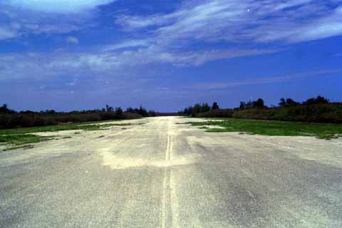
I went to Tinian to find whatever was left of the B-29 base, and possibly (I hoped) find the bomb pits where Enola Gay and Bock's Car were loaded. (The Little Boy and Fat Man bomb designs were too large to be rolled under a B-29; therefore, special concrete-lined pits were constructed for the purpose of holding the atomic weapons below ground level prior to loading. The bomber aircraft would be rolled over the pit, until the bomb bay was directly above the bomb. Then, the bomb would be hoisted into the aircraft weapon bay.) Tinian, I discovered, was something of a backwater. (In 1990, the islanders were debating the pluses and minuses of legalized gambling on the island, to boost the local economy by increasing Japanese tourism. I don't know if they finally did it or not.)
Tinian is about the same size and shape as Manhattan, and
when U.S. forces occupied it during the war, they laid out a
system of roads with the same general plan and orientation as on
Manhattan. The main north-south road, for example, is Broadway,
and it runs parallel to the other main north-south road, 8th
Avenue. I inquired in the main town, San Jose (at the south end
of the island), about the main wartime airfield (at the north end
of the island), but nobody knew much about it. So, I drove north
on Broadway. The road became less and less maintained, until,
nearing the north end of the island, it degenerated into almost a
trail, with forest growth on either side and overhead that was
just barely wide enough for the car to pass through. The trail
ran near some beautiful beaches. Then it turned back into the
forest, and seemed to wind around. I began to think that I might
not find the airfield, and then all of a sudden I broke out into
the clear, and in front of me was an 8000-ft runway (as measured
later on my car's odometer). It was grayish and
weathered-looking, but very driveable (only some weedy growth
crawling out onto it here and there). I drove around on the
taxiways, and found four parallel runways oriented nearly
east-west. I drove the car to the end of one of them, and floored
it to the other end. I was imagining the takeoff run in a B-29.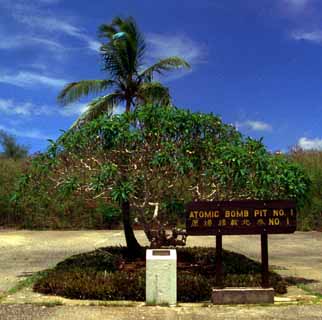
Other than the runways, nothing seemed to be left of the old facilities. No buildings were to be seen. The forest had grown right up to the edges of the runways and taxiways. But then, at the northwest corner of the airfield, just off one of the taxiways, I found a little clear area, triangular-shaped, still covered by concrete. The taxiway connected to one of the triangle's corners, and at each of the other two corners was a concrete-walled pit. Both pits were filled in with dirt, and were sprouting small trees that spread out over neatly tended little Japanese-looking gardens. Next to one pit was a wooden sign, with letters cut into it by a router (like signs in National Forests in the U.S.). The letters were painted yellow. The letters said, "Atomic Bomb Pit No. 1," and below this message was a set of Japanese characters that presumably said the same thing. Next to the other pit was the same kind of sign, labeled Atomic Bomb Pit No. 2. Beautifully kept, and no clue as to who came out into the jungle to tend these little plots. Slightly spooky.
A plaque marks the location of where the atomic bombs were loaded for their flights to Hiroshima and Nagasaki.
The runway and bomb pits can be seen at anytime, no tours are offered.
As interpolated from a USGS topo map, the bomb pits are located at east longitude 145 deg 37' 53", north latitude 15 deg 04' 58"
To get to the runway and bomb pits, drive north from the Tinian airport (or from San Jose) on Broadway. Stay on the road, even as it degenerates inside the forest. You'll eventually pop out on the runway/taxiway complex. Drive to the taxiway at the northwest corner of the northernmost runway. That's where the bomb pits are located.
To get to Tinian first go to Guam, then get a commuter flight north to Saipan, then hop south a few miles to Tinian on another commuter flight. Rental cars are available at Tinian airport.
![]() Photographs and text © 1997 by Frank Sanders and used
with his permission.
Photographs and text © 1997 by Frank Sanders and used
with his permission.